Summer 2019 MAP Projects
Jerod Weinman
Abstract
This document provides a background on summer 499 (MAP) for Grinnell
students and the high expectations I have for my summer students.
Contents
1 Introduction
2 Project Overview
2.1 Background
2.2 Improving Text Detection
2.3 Aligning Maps
3 Approximate Schedule
4 Activities
4.1 Spring
4.2 Summer
4.3 Fall and Beyond
1 Introduction
The general focus of my research is in machine learning for computer
vision. Because reconstructing a 3-D image from a 2-D projection is
a difficult inference problem, some computational machinery is necessary.
Furthermore, understanding and extracting meaning from images is a
problem that has been solved by humans, but remains elusive for machines.
Because it is nearly impossible to specify and hand-code models for
these tasks, machines must be endowed with some amount of learning
capabilities.
The application context of the projects for this summer is extracting
information from historical maps. The projects will focus on finding
text, and aligning map image contents with known political boundaries.
2 Project Overview
2.1 Background
The application for the project, already underway, is recognizing
place names (toponyms) on historical map images. While many old maps
are being scanned and distributed online, their contents remain largely
impenetrable to automated search. This project works change that by
automatically detecting and recognizing the text in scanned map images
to enable indexing and search of these images the same way we now
search web pages and (more recently) digitized books.
The following resources describe some of my prior work in this area
in (in order of increasing detail):
The work described above provides some background context. Ongoing
work in progress has also added a computation stage dedicating to
detecting the text in maps. Its pipeline is adapted from the following
paper.
Projects for the summer will involve refining our existing text detection
work and starting a new sub-project using graphical information to
align map images to GIS hydrography and border data.
2.2 Improving Text Detection
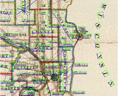
Our current approach to extracting the text regions from maps suffers
from two primary limitations. The first is that it does not deal well
with curved text (that is, text written along a curve, rather than
a straight baseline). This is primarily because the current model
can only produce a rotated rectangle to cover a region it thinks is
a word. This project will explore alternative formulations or follow-up
strategies to remedy this problem. For example, several rectangles
might be linked (based on learned criteria) to indicate they cover
a single word, or the model might be altered to produce curved regions
from the start.
The second limitation of separating text regions from a map image
is that the predicted rectangle often fails to cover the complete
extent of a word, essentially chopping off some leading or trailing
characters. The likely cause for this behavior is that the effective
field of view for decision is too narrow. At each image location,
the model predicts whether there is text at that location, and if
so, what the size of the rectangle is around that text, relative to
the current location. In theory the model has information about features
of the image in large radius around the location, but recent work
has shown that in practice, the effective radius of information (called
the receptive field) is drastically smaller. Another approach
might explore alternative model architectures to improve the effective
receptive field size or develop secondary iterative search procedures
to expand the (often limited) initial prediction made by the current
model.
Recent work on a related problem of finding and reading text in arbitrary
photographs has shown that integrating the detection and recognition
process during model learning improves results. Unfortunately, voluminous
quantities of training data are required to leverage this fact. Previous
MAP students dealt with this problem in part by creating a mechanism
for synthesizing artificial map text for training a text recognition
module. Another project would expand the capabilities of the synthesis
system to generate artificial data suitable for training a text detector
with the ultimate goal of training an end-to-end reader that seamlessly
detects and recognizes text.
Human labeled text regions (left) and automatic text detections (right)
with text baseline orientation in blue. (Original map Copyright Cartography
Associates; creative commons licensed.)
Good candidates for this project will be students who have taken (in
approximate order of preference) CSC 262, MAT 215, CSC 301, or
CSC 207. Willingness (and a demonstrated ability) to learn Python
and Tensorflow before the start of the project is required.
2.3 Aligning Maps
Another student project related to the same overall task of extracting
information from maps but orthogonal to those presented so far involves
using modern day political and geographic boundaries from a GIS system
to align map images to world atlases. Previous project work used the
placement of the text on a map and the matching of this text to real-world
place names to infer the function that would convert a map image pixel
location to a latitude and longitude. Because the text is relatively
sparse on a map, this calculation is imperfect and would be improved
by using the cartographic contents of the image.
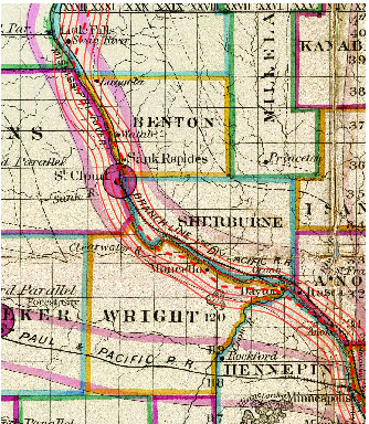
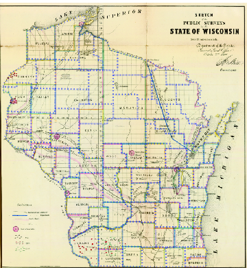
Models for georeferenced linear features: rivers (left) and boundaries
(right). (Original maps Copyright Cartography Associates; creative
commons licensed.)
Good candidates for this project will be students who have taken (in
approximate order of preference) CSC 262, MAT 215, CSC 301, or
CSC 207. Willingness (and a demonstrated ability) to learn Matlab
before the start of the project is required.
3 Approximate Schedule
This schedule largely follows that officially approved by the division.
However, since other (off-campus) options have different schedules,
I will need to know if you are considering other opportunities, what
the schedule is, and whether you are likely to choose an off-campus
opportunity if accepted.
- March 3:
- Applications due. Submit responses to my
questions to me.
- March 8:
- Initial selections announced (pending funding approval
by the College) via e-mail.
- March 15:
- Decisions due.
- Week of 2 April:
- First meeting.
- Unspecified other dates:
- Additional meetings.
- April 22:
- Draft MAP proposal due.
- April 29:
- Revised MAP proposal due.
- May 6:
- Final MAP proposal due.
- May 20:
- Commencement.
- May 21:
- Brief literature survey due.
- May 24:
- (or earlier): Other background preparation (e.g., languages,
advanced topics) completed.
- May 27:
- Summer research begins. (Tentative date)
- August 2:
- Summer research concludes. (Ten weeks hence)
4 Activities
I have very high expectations of my summer research students.
Among other things, I expect my students to begin their summer research
during spring semester and continue their summer research into fall
semester (and sometimes beyond). By applying for summer research you
are agreeing to meet these expectations if I take you on as a research
student. You are unlikely to receive explicit credit or compensation
for work in the spring and fall.
I also expect my students to be self-reliant. While I do my best to
be around, I expect you to be able to do many things on your own or
with a small group.
I expect your graded research milestones (eight in all) to conform
to the highest standards of writing at Grinnell.
The remainder of this section is an overview; you may find many more
details in the syllabus.
4.1 Spring
Topic Preparation
You are expected to begin your background research during the spring.
In particular, you must identify at least four scientific papers on
related projects. You are also encouraged to use the web to aid your
search. Some useful resources are:
Some of the related conferences to find this work are
- CVPR
- Computer Vision and Pattern Recognition
- ICDAR
- International Conference on Document Analysis and Recognition
- DAS
- IAPR International Workshop on Document Analysis Systems
- GREC
- IAPR International Workshop on Graphics Recognition
- ICCV
- International Conference on Computer Vision
- ECCV
- European Conference on Computer Vision
- ICPR
- International Conference on Pattern Recognition
- ICIP
- International Conference on Image Processing
- ICASSP
- International Conference on Acoustics, Speech, and Signal
Processing
and some related journals include
- PAMI
- IEEE Transactions on Pattern Analysis and Machine Intelligence
- IJCV
- International Journal on Computer Vision
- IJDAR
- International Journal on Document Analysis and Recognition
- TIP
- IEEE Transactions on Image Processing
though there are of course many, many others. Once you have identified
potentially useful resources, if you cannot find an author preprint
online (they nearly always are), consult with the librarians about
obtaining a copy of an article or conference paper.
You will email me your list of papers (with complete citations) by
the date above.
Skill Preparation
If your project will require a programming language, data interface,
or library that you do not yet know, you are expected to begin learning
them. You need not master any of them, but should develop comfort
and familiarity.
4.2 Summer
During the summer, you are expected to work full-time on the project
(40 hours per week for ten weeks). This work will include regularly
scheduled group meetings. See the syllabus
for more information.
Topic Preparation
For the first week of summer research, you will continue your preparation
from the Spring, developing a survey of the state of the art in whatever
project you've decided to undertake. You should prepare a short survey
paper. This will serve as an introduction/literature review for a
later paper. On the first day of the second week, you will give a
public presentation of your work.
Core Research and Development
For the next eight weeks of the summer, you will work on your project,
using what you've learned during preparation for guidance. Some of
this time may be spent developing skills. We will have a full-group
meeting several times per week. Each group will present at least once
per week at that meeting.
Writing
Throughout the summer, you will work on a five-to-ten page paper describing
your work and placing it in the context of related work. Your paper
should meet the highest standards of writing at Grinnell. I hope our
work will progress to the point that you will be able to submit a
version of this paper to a scholarly conference or journal. (I will
provide significant assistance in developing the submitted version,
in which case I will probably ask to be listed as a co-author.)
4.3 Fall and Beyond
Poster Presentation
You will create a poster describing your work and present it at the
Grinnell Science Poster Seminar (typically during parents' weekend).
Internal Public Presentation
You will give a twenty-five or fifty minute presentation on your work
as part of the Computer Science Department's Thursday Extras series.
External Conference Presentation
If your work is submitted to and accepted by a conference you are
expected to attend and present your work. (Funding is available from
the Dean's office for you to attend the conference.)
External Pew Presentation
You may submit your work to the Pew Midstates Science and Mathematics
Consortium Fall Symposium on Undergraduate Research in the Physical
and Mathematical Sciences. If your work is accepted, you must attend
the symposium (including non-CS talks) and present your work (in poster
or talk form). You must give at least one practice talk before going
to the conference.
Acknowledgement
With thanks to Professor Sam Rebelsky for many elements of Section
4.